What is HGIS?
Historical Geographic Information System, or HGIS for short, is a mapping tool that can display and analyze data. It is particularly interesting when analyzing change over time because you can create different sets of maps, for, let’s say wheat production in Saskatchewan in the 1950s and the 1960s. Taking this as our example, we could play around with all sorts of variables like different types of wheat, different years, and differing regions within Saskatchewan in order to analyze and showcase research. All in all, it is a very useful tool that can visualize and present very complicated data in a very simplified manner.
My experience using HGIS
In order to display that information, GIS software like ArcGIS needs to be used. ArcGIS is an Esri mapping software launched in 1999. This is probably the most complicated software that I have ever used, considering I don’t have much computer science experience. The tutorial that I followed was really helpful and straightforward but what it failed to explain sometimes was why and how the different steps that I was taking were affecting my map. Had I had more time, I would have preferred to have gone slower in order to better understand the different features of the software. However, by the end of the lab, I think I had finally got the hang of understanding and using the interface, to a limited extent.
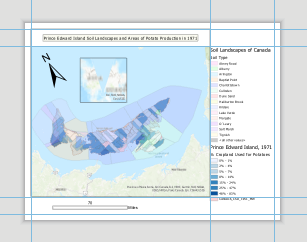
Here is the map that I was able to create:

The main issues that I run into were that the circle thing above the map was blurry and I tried to get it to focus since I needed to zoom into Prince Edward Island, but the software was not cooperating. Also, for some reason, my title is not showing up here although it was visible in the software. Other than that, I made a few stylistic choices that make my map differ from the tutorial’s map.
Verdict
Personally, I am fascinated by HGIS’ potential. The StoryMaps platform blew me away. Even in this map that I created, the amount of data on there is crazy. However, there is the initial difficulty in learning the software because it is not something that comes intuitively. I feel like the real joy in HGIS comes after learning to use the software.
Thus, I would argue that ArcGIS or other such platforms should be taught in digital humanities, especially in history because it is only going to enrich research and expand undergraduates’ quality of scholarly work.
Samantha Huckerby
I think you touched on GIS’ most useful feature: it’s ability to display a lot of data in a rather simplified way. Visualizations can be so helpful. Do you see yourself using HGIS in your project or learning more about how to use it in the future?
waa878
Thanks for the feedback Sam. I would love to learn more about HGIS in the future! For this project, I don’t see myself going too deep into it just because of the time constraint.