Gossamer Network is a digital history project created by Cameron Blevins, Yan Wu, and Steven Braun. Gossamer Network is intended to act as a companion piece to Cameron Blevins’ academic book Paper Trails: The US Post and the Making of the American West. The website acts to visualize the incredible amount of data that is behind and explain through written portions, the argument that Cameron Blevins is making. This argument being that the key institution in securing western American expansion was the U.S. Post Office. Blevins, who wrote the content of Gossamer Network, is a Professor of U.S. History and Digital Humanities at the University of Colorado Denver whose research has focused on western American history, with a significant portion of his work also exploring the use of digital tools in both historical and text-based projects such as his work with the diary of midwife Martha Ballard. According to the about page Gossamer Network itself had website work done by Yan Wu a graphics and data reporter, with additional design by Steven Geofrey Braum a data visualization and information design assistant professor who is currently teaching at Northeastern University.
Gossamer Network works well within a desktop environment, barring some occasionally awkward loading and better than initially expected within a mobile environment, when used in landscape mode. The basic use of the website involves scrolling down which presents the audience with both new text and often new visualizations. These visualizations can be hovered over and clicked on for more information, to change the visual or to highlight a portion of the current visual. The website is divided into 9 sections that can be switched between using a bar at the top of the screen that follows the audience. Each section excluding the introduction is divided into a period of time and arranged in chronological order.
When read in order Gossamer Network acts like a traditional academic article in many ways utilizing prose with conventional citations. Where the real difference comes is in the visuals utilized alongside this argument. By placing Gossamer network within a digital environment Blevins doesn’t have to be restricted by the limitations of physical publication of maps. This allows the reader to both see the massive and detailed data related to Blevins’ argument and interact with it in a way that is impossible to accomplish with physical maps.
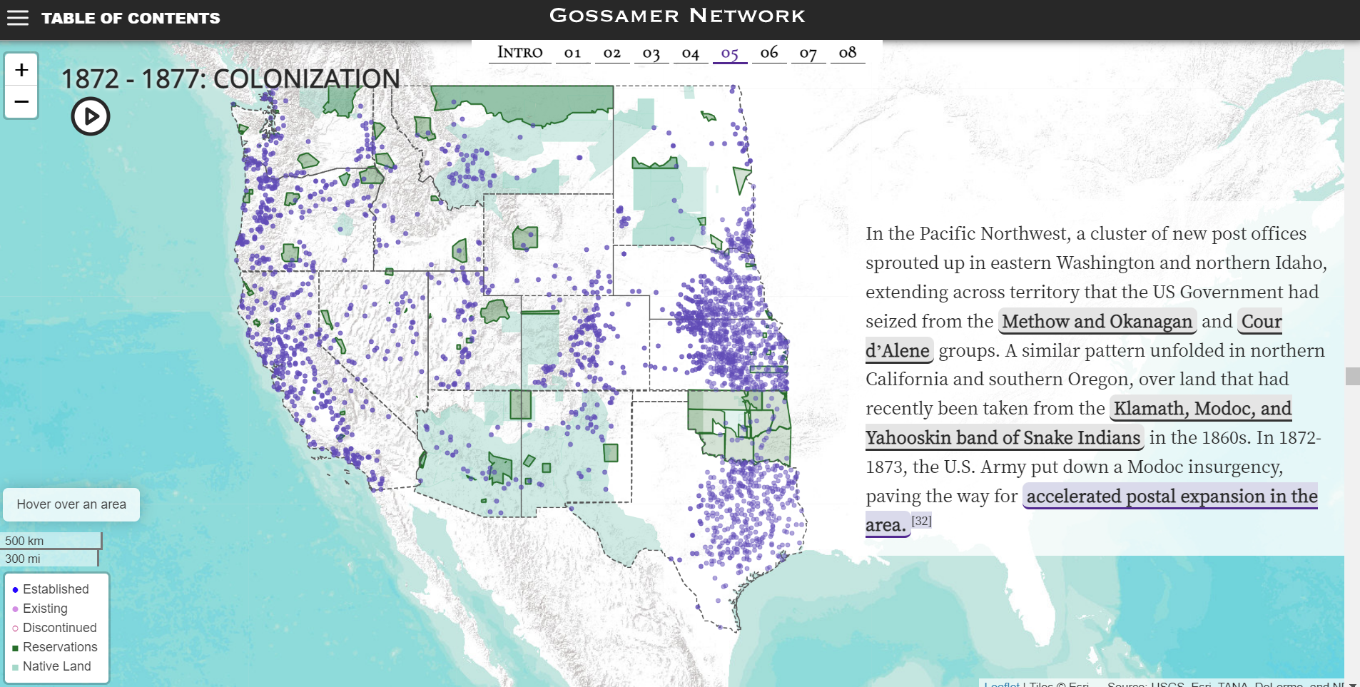
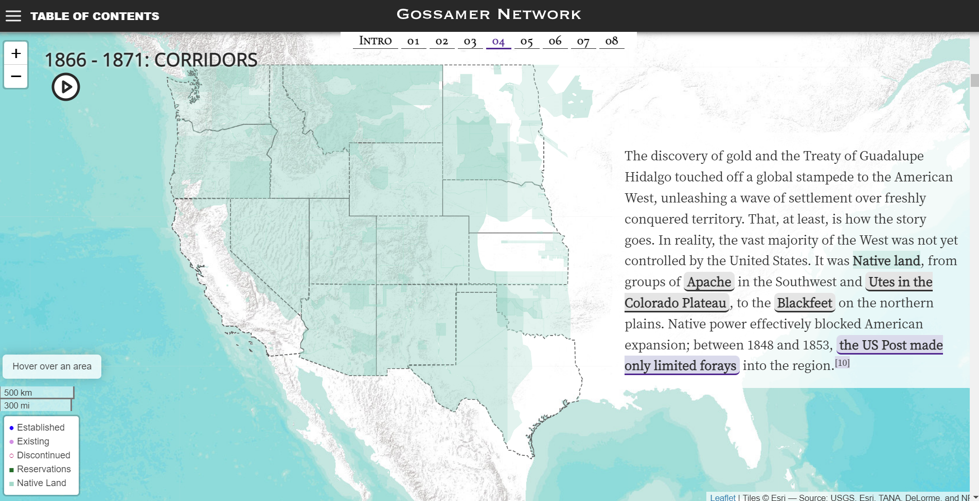
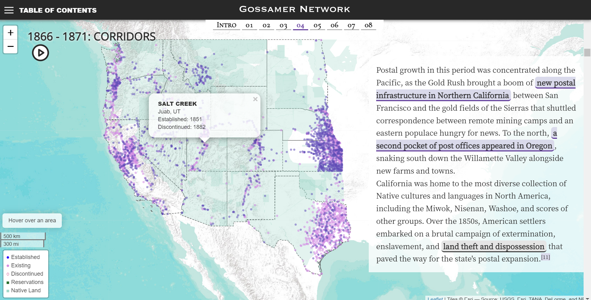
For example, the second block of text in the first section titled “1848-1853: Forays” contains prose that outlines the traditional notion of western settlement in the United States. The prose then challenges this as ignoring the fact that the United States didn’t really control this land, but rather Indigenous populations did. The audience can then mouse over sections with different Indigenous groups names within the text to see their associated territory on the map and to see the limited number of post offices within the West at this point in time. By showing the Indigenous control of land in contrast to the number of post offices it shows the limits of American government control in a clear and concise way that through interaction engages the audience. In addition, the audience member can hover over the map directly to see what territory is associated with what group including those outside of the scope of the attached text. This ability to go beyond what is discussed in the text is only increased in further visuals, which allow interaction with other elements. For example, other sections provide the ability to click on every post office mapped to find the name, location and operational years.
What makes this interactivity and use of visuals all that more astounding is the massive data sets that back it up, with three data sets from US Post Offices, Atlas of Historical County Boundaries, and Invasion of America integrated into this one source. The only real criticism I have would be of some of the language used in Gossamer Network which occasionally uses the more outmoded term, at least in the Canadian context, native in place of Indigenous.
Gossamer Network then is perhaps one of the best examples of what working within a digital environment academically can look like. Not only is Blevins’ data on a scale that would have been unfeasible before the introduction of digital tools, but it is presented in a way that would have been impossible outside of a digital environment. For me then this project is both an exciting look at what can be done with digital tools and techniques, but also raises some interesting questions as to how the academic field might have to adjust from a solely print model to a hybrid model to be able to recognize and incorporate this scholarship done in a digital environment.
Very well written, Alan. I like your final thoughts regarding the feasibility of this project and its connection to digital tools. Do you think that utilizing these interactive maps more in scholarship would be worth the risk of the software becoming outdated? Flash Player powered quite a few visualizations on the web, but since it’s gone, we have a harder time viewing those visualizations. Books don’t exactly go out of date the same way, so what are your thoughts?
Hello,
I think backing technology becoming outdated is a risk to be sure. With that in mind I still believe that the opportunities online environments present are worth the risk as both a teaching and a research tool. While the demise of Flash may have made a number of project unviable the backing data for those projects if preserved in opensource formats is almost certainly available to be transposed into new formats. I think we need to view the maintenance and upkeep of these projects is the main tradeoff to the online environment. It is also probably worth pointing out that this project accompanies a physical book which contains a smaller number of maps based on the digital ones constructed for this website.