What are Tropical Cyclones?
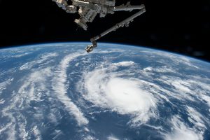
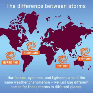
Tropical cyclones are rotating low-pressure systems that occur on oceans, near higher climate areas.(1) Hurricanes, cyclones, and typhoons are all tropical cyclones. They are all the same type of storm but are named differently based on their locations. Hurricanes occur in the Northeast of the Pacific ocean and in the Atlantic ocean. A typhoon occurs in the Northwest of the Pacific ocean. A cyclone occurs in the south of the Pacific ocean and in the Indian ocean.
All is Possible- https://www.flickr.com/photos/wheatfields/10834321135
Hurricane Structure
Hurricanes rotate in a counter-clockwise circulation when viewed from above and can have wind gusts of 119 km/h or higher.(2) They have an eye, an eyewall, and rain bands. The eye is the centre of the storm and is the calmest area. The 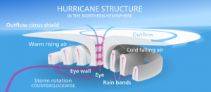 eyewall surrounds the eye and it is where the winds are the strongest. The rain bands are bands of clouds and rain that spread over a wide area of land/water.(2)
There are 5 categories of hurricanes that describe their wind speeds. The higher the wind speeds, the higher category of hurricanes. These categories are…
Wikipedia- https://en.wikipedia.org/wiki/Eye_(cyclone)
Category 1 → 119 km/h – 153 km/h
Category 2 → 154 km/h – 177 km/h
Category 3 → 178 km/h – 208 km/h
Category 4 → 209 km/h – 251 km/h
Category 5 → more than 552 km/h
Why is it Important to Predict Them?
One main reason why is it very important to predict hurricanes and tropical storms is because they are very damaging and even life-threatening. The ability to predict hurricanes allows emergency personnel to prepare for the impact of the potential storms. Being able to prepare civilians for the potential risk of each hurricane will determine evacuations and safe preparations. Prediction of hurricanes allows preparing hurricane warning areas. These warning areas allow for people to take shelter and conduct evacuation plans if the risk is high enough.(3)
There are different risk factors to be considered when predicting hurricane behaviour and determining the necessary emergency measures that should be taken. When determining an evacuation, there are two major factors that are considered the time in which it will take everyone to safely clear the hurricane warning area and the time in which the hurricane is predicted to arrive. The clearance time of the evacuation refers to the amount of time to have all roads and highways cleared of vehicles involved in the evacuation. The clearance time is determined in relation to the time predicted for the storm to arrive at landfall.(3) The clearance time is determined by observing many factors, such as time for people to secure their homes, pack belongings and safely evacuate the warning area to a safe destination.(3) The evacuation is conducted only if there is enough time to safely conduct the procedure because the hurricane arrives.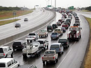
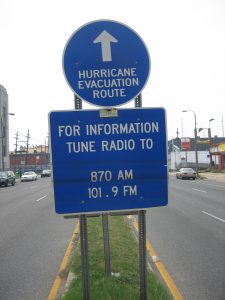
Deciding when a Hurricane Warning area should evacuate is determined by one of the two following indications, whichever takes place first. Either wind of 63 km\hr an abundance of storm surge indicator, which is an abnormal amount of water in an area due to the tropical storm.(3) If there is a hurricane in the area, either an evacuation order or mandatory evacuation order may be issued. The Evacuation Order means people are strongly advised to evacuate the Warning Area but may use their own discretion, although it is not advised. The Mandatory Evacuation Order is issued by government personnel and requires everyone to evacuate the area involuntarily for their safety.(3)
Wikipedia- https://commons.wikimedia.org/wiki/File:Residents_evacuating_ahead_of_hurricane_bret.jpg
Wikimedia- https://upload.wikimedia.org/wikipedia/commons/c/cb/Hurricane_Route_sign_Tulane_Avenue_floodlines.jpg
History of the Satellite Detection System
https://www.youtube.com/watch?v=zCxxQcvBwKw
In the 1940s, hurricanes were a total mystery. There were no instruments that could tell you what was out there. In 1944, Harry Wexler flew into the Great Atlantic hurricane in hopes to learn more about them. His trip was successful however he only learned more about the structure of hurricanes. He was discouraged by the number of dead and understood that in order to save lives, a warning system would have to be put in place. Wexler got inspired with the prospect of putting satellites in space. Eventually, this became a reality.
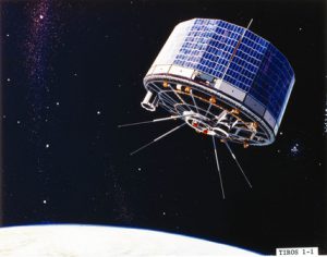
The Television Infrared Observation Satellite Program (TIROS) was NASA’s first set of satellites sent up to space to determine whether satellites could be useful to study weather. The program was designed to aid and study the weather on Earth. In total 10 satellites were launched as a part of the TIROS program. The TIROS program ran from April 1st, 1960 to July 1st, 1967. The TIROS program captured many of the first photos of hurricane’s and helped answer Earth related questions such as “should we evacuate the coast because of hurricanes?”.(8)
Science and Society- http://www.ssplprints.com/image/87572/nasa-tiros-1-meteorological-satellite-1960
The Nimbus program was the successor of the TIROS program designed to collect more data about Earth and its weather. The Nimbus program consisted of 7 separate satellites the first one being launched on August 28th, 1964 and the final one being launched on October 24th, 1978. The Nimbus program was supposed to specifically research the effects major storms such as hurricanes had on the Atmosphere.(9) The Applications Technology Satellite Program (ATS) was 5 satellites launched for the purpose of a further meteorological survey of the Earth. The program produced some of the first colour images of storms such as hurricanes. The program’s first satellite was launched on December 7th, 1966 and the final satellite was deactivated on August 12, 1969. The Synchronous Meteorological Satellite Program (SMS) was a program that consisted of two satellites that were launched by NASA. The SMS program showed that geosynchronous orbit worked well for meteorology. Especially for forecasting and tracking major storm systems such as hurricanes. The first satellite was launched on the 17th of May in 1974 and the second one was launched on the 6th of February 1975. The SMS program directly led to the GOES program.(10) The Geostationary Operational Environmental Satellite Program (GOES) is a current mission operated by NASA. The GOES program currently contains 12 satellites and is currently adding more in the future. The Goes program which started on May 17th, 1974 when the first satellite was launched was designed to accurately predict and monitor weather from across Earth. The mission placed special emphasis on predicting weather events such as thunderstorms, fog, floods, and especially systems that paused a bigger risk to humans such as tornadoes and hurricanes. As well the GOES program was designed to support search and rescue, monitor environmental situations, improving forecasting, and to provide warning for solar disturbances.(11)
NASA- https://www.nasa.gov/content/goes-overview/index.html
The QuikSCAT was launched on June 19th, 1999. The purpose of the QuikSCAT satellite was to monitor global ocean surface winds. The QuikSCAT program was very successful as an early warning system for hurricanes. The QuikSCAT satellite was also very useful for monitoring hurricanes as well. After an antenna failed on the satellite it was ended on November 23rd, 2009.(12) The tropical rainfall measuring mission was a joint mission between NASA and JAXA. The mission was designed to study rainfall and the mission helped improve the understanding of tropical cyclone structure and how they evolve. The mission ended on April 15th, 2015 when the satellite failed.(13)
Facts of Hurricanes that Occurred before and after the Use of Satellites
In 1944, a devastating tropical storm named “The Great Atlantic” occurred. This hurricane started to develop in Puerto Rico on September 9th and moved all the way northward to New Jersey, the United States by September 14th and effects of the storm moved into New Brunswick, Canada on September 15th.(6) This hurricane developed into a Category 4 and hit some areas as a category 3. The eastern coast of the United States and Canada felt winds upwards to 1440 km per hour. The Great Atlantic killed 390 people.(6) This storm occurred before satellites were used in storm predictions.
In 2017, after the innovations of hurricane predictions via satellites, Hurricane Harvey hit the states of Texas and Louisiana. Hurricane Harvey was a category 4 hurricane and hit landfall 3 different times.(7) The first was August 25th when Harvey hit Port Aransas and Port O’Connor. The winds speeds were about 209 km per hour when it tore through these two cities. In addition, Harvey hit landfall again on Houston, Texas on August 26th.(7) The hurricane remained in Houston for four days and flooded the city before hitting landfall again on August 29th over Port Arthur and Beaumont. Onward, Harvey dropped 10 inches of rain onto Nashville on September 1st. Hurricane Harvey dropped 26in of rain in just 24 hours. (7)This is a record rainfall for any storm in the United States. Harvey is responsible for damages costing approximately $ 190 billion USD. On top of that 82 deaths were caused by Harvey as well.(7) While it may be impossible to save the property from being damaged by natural disasters, with a warning, citizens are able to take shelter from predicted storms.
Both of the hurricanes above were classified as Category 4 storms. NASA was able to take satellite images of Hurricane Harvey growing and predict great amounts of rainfall.(7) Being able to predict, when and where a hurricane may hit landfall can readily prepare populations for evacuations. As stated above, The Great Atlantic killed 390 people, while Harvey killed 82, 308 fewer people. While the economic damages may be more significant from Harvey, consideration of today’s economy and the mass development in today’s society must be considered. By looking at death toll alone, the prediction of hurricanes via satellites has a large impact on the lives of civilians in the warning areas.
How do Satellites Work?
https://www.youtube.com/watch?v=zfVeB4s8WWk
Satellites work by sending radio wave signals to the receiver antennas that are located on Earth and whoever receives the information then interprets the signal.(4) The first satellite was launched in 1957.(18) The information received includes locations of the satellites, the health of satellites, and pictures taken from the satellites.(4) This is important because it gives NASA a bird’s eye view and radio waves to Earth.(18) Satellites travel around the Earth at about 7 km per second, and as the Earth turns the satellite eventually covers the whole surface.(4) While it’s doing this the satellite is scanning what the weather is doing at that moment so that meteorologists can try to figure out what may be on its way. Satellites are better than telescopes because it flies above the clouds, molecules and dust and prevents a blocked view from Earth.(18) Satellites have two main parts that include an antenna and a power source. (18) The antenna is the part of the satellite that sends and receives signals back to Earth while the power source includes a solar panel. The satellite balances out with the Earth’s gravity and the satellites speed while orbiting around the Earth going from West to East.(18)
Satellites provide us with information about clouds, oceans and the Earth’s surfaces which include gases, land and ice. Some satellites are used to watch for dangerous rays coming towards the Earth. Explore asteroids and comets, stars and the origin of planets. There are many reasons why we would need to know this information including helping the public, farmers and EMT workers. Satellites can crash into each other and circulate towards and close to other planets which allows examining water on Mars or close up of planets’ rings.(18) The receivers on Earth are located all around the world and are in many different shapes and forms. They are used for many things such as television, radio, or even locating things. However, when talking about the satellites that detect weather before it happens it is a different kind of receiver. For detecting weather there are several ground labs on the surface which take in the radio signals from the satellite which is data. That data is then sent to the main office where it can be distributed and that is where meteorologists get a hold of the data and interpret it. The receivers on the ground communicate with the satellite by sending uplink signals.(5) Then the satellite sends the data down through a signal called the downlink on a different frequency so it doesn’t interfere with the uplink.(5) Weather satellites use a frequency between 460 and 470 MHz The downlink is sent from the satellite to a different receiver on the ground then the one that sent the uplink and the information is interpreted.(5)
Types of Satellites and their Uses
Geostationary Satellites are satellites that orbit around the Earth’s equator and are slow-moving.(17) They are used for…
-
- Communication
- GPS.
Polar Satellites are satellites that orbit around the Earth’s poles and are fast-moving.(17) They are used for…
-
- Monitoring weather
- Observing the Earth’s surface.
 SEOS-http://www.seos-project.eu/modules/remotesensing/remotesensing-c02-ws01-t.html
Satellites orbiting in space
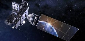
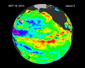
NASA has many resources and capabilities that enable them to gather data that benefits the populations affected by hurricanes. One of their main resource is sending satellites into orbit to collect data of growing hurricanes and hurricane behaviour. There are several different satellites that are used for different data collection. Satellites such as Aqua and Terra are able to view the entire surface of the Earth every day or two.(19) NASA-NOAA’s Suomi NPP (National Polar-orbiting Partnership) satellite provides information about the precipitation within the clouds so forecasts can be made three to seven days in advance.(19) CALIPSO (Cloud-Aerosol Lidar and Infrared Pathfinder Satellite Observation) uses infrared and visible imagers to see how clouds and aerosols form and develop, and how they affect our weather and climate.(19) Jason 2 measures the sea surface height and temperature. All of these satellites help NASA determine behaviours in the weather that may indicate future storms. The CloudSat satellite is able to detect precipitation from space.(19)
 NASA-https://spaceplace.nasa.gov/earth-card-game/en
Wikimedia-https://commons.wikimedia.org/wiki/File:NASA-NOAA%27s_Suomi_NPP_Gets_an_Infrared_look_at_Typhoon_Soudelor_(20436605746).png
NASA- https://www.jpl.nasa.gov/spaceimages/details.php?id=pia17809
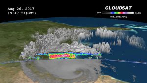
NASA- https://www.jpl.nasa.gov/spaceimages/details.php?id=PIA17392
Recent Improvements
A major advancement in the recent technology of hurricane prediction by satellites is the NASA mission that launched in December of 2016. This mission is called Cyclone Global Navigation Satellite System (CYGNSS).(15) This mission consists of is 8 satellites that will disperse and orbit around Earth. These satellites will be used in the study, detection and prediction of hurricanes. What is unique about this mission is the ability for the satellites to enter into the eye of the hurricane.(15) This is a place that has never been explored and will benefit the predictions and studies of future hurricane storms. One of the main goals of CYGNSS is to measure the winds speeds by the use of radio signals.(15)
Since the collection of data began in March of 2017, CYGNSS’ first hurricane storm analysis took place on Hurricane Harvey.(16) The satellite overpassed the storm measuring the winds in the morning of August 25th and by that evening, the rainfall began. The satellite’s take data and measurements from both the ocean and land.(16) The data collected from observations over the water can predict surface wind speeds. While observations over land can sense and image rainfall and flooding.(16)
https://www.youtube.com/watch?v=-id3oqrs_pc
Conclusion
It is very important to be able to predict hurricanes and other storms before they occur. They are predicted through the use of satellites located in space. Satellites communicate by sending signals to and from space. Meteorologists then use the information to determine when the hurricane will make landfall and how they develop. Without the use of satellites, there would also be no way to see weather before it happens and no one would be able to see what kind of weather is on its way. Hurricanes are very destructive and can be deadly especially when they make landfall. This is seen in the world’s history. Hurricanes are only going to continue occurring so new ways to predict and study them are being explored so more and more lives can be saved.
Bibliography
1. US Department of Commerce, National Oceanic and Atmospheric Administration. “What Is a
Hurricane?” NOAA’s National Ocean Service, 28 June 2013,
https://oceanservice.noaa.gov/facts/cyclone.html2.
2. Dunbar, Brian. “What Are Hurricanes?” NASA, NASA, 13 May 2015,
https://www.nasa.gov/audience/forstudents/k-4/stories/nasa-knows/what-are-hurrican
3. “EVACUATION TERMINOLOGY AND TYPES OF STORMS.” Emergency Management
Chatham County, Chatham Emergency Management Agency, 31 May 2017,
https://www.chathamemergency.org/evacuation-information/evacuation-levels-and-ty
4. Campbell, Ashley- “How do Satellites Communicate?”, NASA, NASA, 05 August 2017,
https://www.nasa.gov/directorates/heo/scan/communications/outreach/funfacts/txt_sa
5. Papiewski, John. “Do Satellites use Radio Waves?” It Still works, 16 Nov. 2017,
https://itstillworks.com/satellites-use-radio-waves-18345.html
“6. 1944- Great Atlantic Hurricane.” Hurricanes: Science and Society, University of Rhode
Island, www.hurricanescience.org/history/storms/1940s/GreatAtlantic/.
7. O’Hara, Kristy J. “Hurricane Irma: Facts, FAQs, and how to help.” World Vision, 18 Sept.
2017, www.worldvision.org/disaster-response-news-stories/hurricane-irma.
8. Nagaraja, Mamta- “Television Infrared Observation Satellite Program”, NASA, NASA, 02 May
2016, https://science.nasa.gov/missions/tiros
9. Williams, David- “Nimbus Program” NASA, NASA, 03 Dec. 2009,
https://nssdc.gsfc.nasa.gov/earth/nimbus.html
10. Williams, David- “ NASA Space Science Data Coordinated Archive SMS Program” NASA,
NASA, 21 Mar. 2017,
https://nssdc.gsfc.nasa.gov/nmc/masterCatalog.do?sc=1974-033A
11. Jenner, Lynn- “GOES Overview and History” NASA, NASA, 3 Aug. 2017,
https://www.nasa.gov/content/goes-overview/index.html
12. Wentz, Frank- “QuikSCAT” NASA, NASA, 11 May 2015,
https://podaac.jpl.nasa.gov/QuikSCAT
13. Braun, Scott- “TRMM” NASA, NASA, 7 Nov. 2016, https://trmm.gsfc.nasa.gov/
14. Salazar, Doris Elin. “Hurricane Watch: How Satellites Track Huge Storms from Space.”
Space.com, Purch, 8 Sept. 2017,
www.space.com/38097-how-satellites-track-hurricanes-from-space.html.
15. Allen, Bob. “CYGNSS Overview.” NASA, NASA, 27 May 2015,
16. “Cyclone Global Navigation Satellite System.” Wikipedia, Wikimedia Foundation, 14 Nov.
2017, https://en.wikipedia.org/wiki/Cyclone_Global_Navigation_Satellite_System
17. “GCSE Bitesize Science – Satellites, gravity and circular motion: Revision, Page 2.” BBC,
BBC,
www.bbc.co.uk/schools/gcsebitesize/science/triple_ocr_gateway/space_for_reflection
satellites_gravity_circular_motion/revision/2/.
18. May, Sandra. “What is a Satellite?” NASA, NASA, 4 Aug, 2017
www.nasa.gov/feature/goddard/how-does-nasa-study-hurricane
19. Hille, Karl. “How Does NASA Study Hurricanes?” NASA, NASA, 14 Aug. 2015,
www.nasa.gov/feature/goddard/how-does-nasa-study-hurricanes.
20. Writer, Hanneke Weitering Space.com Staff. “NASA Satellites Watch as Hurricane Harvey Intensifies Off Texas Coast
(Video).” Space, Purch, 25 Aug. 2017, www.space.com/37943-hurricane-harvey-satellite-video.html.
21. Amadeo, Kimberly. “Hurricane Harvey Shows How Climate Change Can Impact the Economy.” The Balance, 30 Sept. 2017,
www.thebalance.com/hurricane-harvey-facts-damage-costs-4150087.
